The ocean did not begin with a triangle on it. For most of recorded maritime history, the western North Atlantic was simply one of the busiest and most hazardous stretches of water on earth—crossed by cargo ships, military vessels, civilian aircraft and fishing boats moving between the Americas, the Caribbean and Europe. Storms rolled in fast. Reefs sat close to popular shipping lanes. The Gulf Stream moved wreckage far from the point of any accident before search crews could arrive.
Then, in the mid-twentieth century, a shape appeared on the map. It was drawn after the fact, around a collection of losses that had already occurred across different decades, different weather conditions and very different circumstances. A name followed the shape, and the name outlasted every serious attempt to retire it.
The disappearances grouped inside that name are real historical cases. The ships and aircraft actually went missing. The crews were never recovered in most of the famous incidents. None of that is invented.
What is invented—or more precisely, constructed—is the boundary itself, and the claim that something extraordinary concentrates disaster inside it.
The Real Losses That Started the Story
Several of the cases most often cited by Bermuda Triangle writers were genuinely puzzling at the time they occurred and remain incompletely explained in their details, though not in ways that require anything beyond ordinary maritime causes.
Flight 19 is the case most directly responsible for the triangle’s popular momentum. On December 5, 1945, a training flight of five U.S. Navy TBM Avenger torpedo bombers departed Naval Air Station Fort Lauderdale, Florida, for a routine navigational exercise over the Bahamas. The flight leader, Lieutenant Charles Taylor, radioed that his compasses were behaving erratically and that he was uncertain of his position. Radio communications deteriorated. All five aircraft, carrying fourteen crew members total, were lost. A search-and-rescue PBM Mariner aircraft sent to find them also disappeared the same evening with thirteen men aboard.
The Navy’s own investigation pointed to navigational confusion and running out of fuel over open water after Taylor turned the flight in the wrong direction. The 1945 Board of Investigation did not attribute the loss to anything anomalous. Taylor’s compasses were likely functioning; the problem was disorientation in deteriorating weather over featureless water. The Mariner’s loss was attributed separately—a witness on a nearby ship reported seeing a fireball consistent with the Mariner’s known tendency toward fuel leaks.
The USS Cyclops is the other anchor case. The Navy cargo ship disappeared in March 1918 during a voyage from Barbados to Baltimore, carrying around 300 men and a load of manganese ore. No distress call was received. No wreckage was found. The loss remains one of the largest non-combat disasters in U.S. Navy history. The leading explanation involves structural failure—the ship was known to have an inoperative engine and was carrying a notoriously unstable cargo—combined with the possibility of sudden severe weather. The case is genuinely unresolved in its exact mechanism, but nothing about it points away from maritime causes.
These cases were being cited in isolation for years before anyone drew a triangle around them. What changed the story was publication, not the accidents themselves.
YOUTUBE EMBED 1 — PRIMARY SEARCH QUERY: “Bermuda Triangle NOAA explanation documentary”
What Official and Scientific Sources Actually Say
The National Oceanic and Atmospheric Administration, which maintains authority over U.S. ocean geography and marine safety records, has addressed the Bermuda Triangle directly on its official public resources. NOAA’s position is unambiguous: the agency does not recognize the Bermuda Triangle as a defined geographic area with an unusual record of disappearances. The agency notes that the number of incidents reported there is not disproportionate to the volume of traffic passing through the region.
The U.S. Board on Geographic Names, which maintains the official register of place names recognized by the federal government, does not list the Bermuda Triangle. It is not a named ocean feature, a designated hazard zone or an official maritime boundary of any kind.
Lloyd’s of London, the international insurance market that has accumulated maritime loss data for centuries, does not charge higher insurance premiums for ships transiting the area. If actuarial evidence supported an elevated risk inside any identifiable boundary, insurers would reflect that in their pricing. They do not.
The physical conditions of the western North Atlantic—particularly around the Bahamas and the Florida Straits—do present real and well-documented hazards. The Gulf Stream, one of the strongest ocean currents on earth, moves through the area at speeds that can carry wreckage and bodies far from an accident site within hours. Shallow-water reefs are numerous and historically dangerous. Hurricane and tropical storm patterns place the region in a high-risk corridor for sudden severe weather. Water depths drop sharply off the continental shelf, making wreckage recovery difficult. None of these hazards are unusual for a busy ocean; they are simply the ordinary dangers of a heavily traveled route that happens to pass through challenging geography.
The compass deviation stories that became a fixture of Bermuda Triangle lore are also explainable. Magnetic variation—the difference between magnetic north and true north—is a normal navigational reality in the western Atlantic, and navigators are trained to account for it. Some early accounts of compass deviation likely reflect this routine phenomenon being misread by non-specialists after the fact.
How the Triangle Was Built on Paper
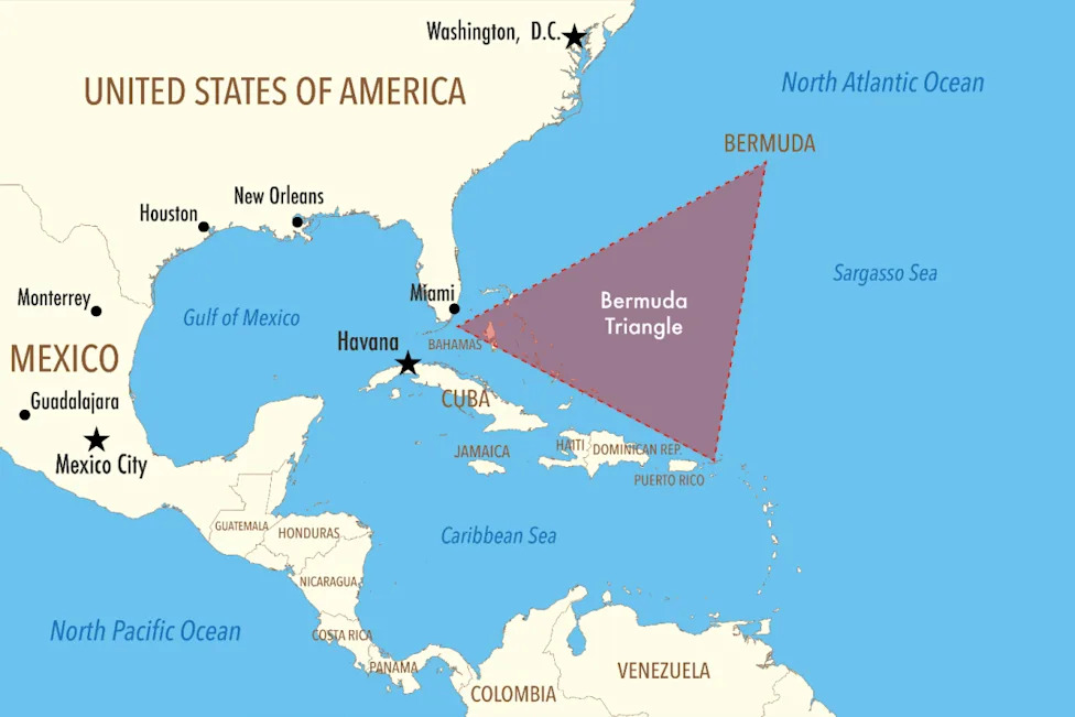
The term “Bermuda Triangle” entered print in February 1964, in an article by writer Vincent Gaddis published in Argosy magazine. Gaddis drew a triangular boundary connecting Miami, Bermuda and Puerto Rico and placed several famous disappearances inside it. The article framed the concentration of losses as evidence of something anomalous. Gaddis expanded the piece into a chapter in his 1965 book Invisible Horizons.
The concept gained its widest reach through Charles Berlitz’s 1974 bestseller The Bermuda Triangle, which sold millions of copies and introduced many of its details—including dramatized accounts of individual incidents—to a global audience. Berlitz’s version of the triangle became the cultural template. It was followed by a wave of magazine articles, television documentaries and paperback books that generally repeated the same cases, sometimes with embellishments not present in the original accident records.
The critical problem the triangle faced from the beginning was its boundary. Gaddis drew one triangle. Berlitz and other writers drew slightly different ones. Some versions extend the shape north toward Chesapeake Bay. Others shift the southern point to Cuba or Haiti. There is no agreed-upon set of coordinates. This matters because the list of “Bermuda Triangle disappearances” changes depending on which version of the boundary you accept. Cases that fall outside one writer’s triangle appear inside another’s. The mystery shifts with the shape, which means the shape is doing more work than the evidence.
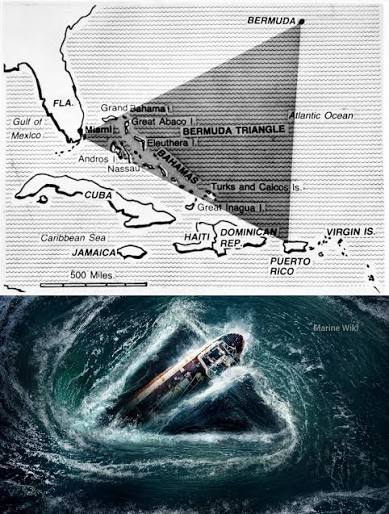
What Gaddis and Berlitz did—and what made their framing so durable—was group selected cases retroactively under one name and one location. Losses that occurred years or decades apart, under completely different conditions, were united by geography alone. Once the triangle existed as a concept, every subsequent loss in the broad area could be added to the file. The list grew because the region is heavily traveled, not because the region is uniquely dangerous.
Where the Theory Makes Its Biggest Leap
The central claim of the Bermuda Triangle mystery is that the region experiences an unusual rate of disappearances—losses that cannot be accounted for by ordinary maritime or aviation causes. This is the leap that the evidence does not support.
In 1975, librarian and researcher Lawrence David Kusche published The Bermuda Triangle Mystery—Solved, a systematic examination of the cases cited in Bermuda Triangle literature, based on primary sources including Coast Guard records, accident reports, Lloyd’s of London records, contemporaneous newspaper accounts and National Transportation Safety Board files. Kusche’s findings were methodical and corrosive to the popular narrative.
He found that many incidents had been misrepresented in popular accounts. Some accidents occurred in storms that were omitted from the triangle versions of the story. Some ships disappeared outside the claimed boundary and were moved inside it by later writers. Some cases cited in popular books could not be confirmed as having occurred at all. Several dramatic disappearances attributed to the triangle took place in the Pacific, not the Atlantic. Dates were wrong. Cargo descriptions were wrong. The names of vessels were sometimes incorrect.
Kusche’s conclusion was pointed: the Bermuda Triangle mystery was, in significant part, a mystery manufactured by the way the stories were selected and retold. Leave out the weather. Leave out the mechanical problems. Leave out the navigation errors. Leave out the fact that the ocean is large and deep and recovers nothing reliably. What remains looks like a pattern. Put the missing details back, and the pattern dissolves.
This does not mean every case inside the claimed triangle has been definitively solved. The USS Cyclops remains genuinely unresolved in its exact cause. Some smaller vessel losses have incomplete records. Debunking the zone as a supernatural concentration of danger does not retroactively explain every individual accident within it. The honest limit of the skeptical case is that ordinary explanations account for the pattern in aggregate, even when individual incidents resist complete reconstruction.
YOUTUBE EMBED 2 — SECONDARY SEARCH QUERY: “Bermuda Triangle disappearance statistics”
The Evidence That Triangle Believers Point To
The most commonly cited physical evidence for something unusual in the region falls into three categories: compass anomalies, rapid disappearances without debris and the sheer number of incidents.
On compass anomalies: the western Atlantic does contain an area—historically near the Bermuda Triangle zone—where magnetic north and true north align closely, meaning a navigator using a compass without correcting for magnetic variation could be operating on nearly correct headings without noticing a problem. This is not an anomaly; it is a geographic fact of how magnetic variation works across the globe. It is not unique to this region, and it does not explain how vessels would disappear because of it.
On disappearances without debris: the Gulf Stream moves at two to four miles per hour through the Florida Straits, with surface speeds accelerating further offshore. A vessel that sinks or breaks apart in this current can have its debris dispersed across hundreds of miles of open ocean within a day or two. The deep water offshore drops to thousands of feet over relatively short distances from the coast. These conditions make wreckage recovery genuinely difficult, and the absence of recovered debris from some cases is real. But difficult recovery conditions are not evidence of a supernatural mechanism. The same conditions apply to many ocean regions.
On the number of incidents: the Bermuda Triangle encompasses one of the most heavily trafficked ocean regions on earth. The Florida Straits carry enormous volumes of recreational boating, commercial shipping and civilian aviation. A higher raw count of incidents in a region with higher traffic is expected, not anomalous. The relevant comparison is not how many incidents occurred, but whether the rate per vessel or per flight mile is elevated. The available data, including insurance records and Coast Guard loss statistics, do not show an elevated rate.
A popular theory claims that methane hydrate deposits on the ocean floor could release sudden gas eruptions capable of sinking ships and causing aircraft to lose lift. Experiments have shown that dense enough methane concentrations can reduce water buoyancy, but no documented evidence links this mechanism to any specific Bermuda Triangle incident, and geological surveys of the region have not established the kind of active hydrate deposits the theory would require.
What Independent Sources Can Verify
Setting aside the supernatural framing, several things about the Bermuda Triangle are fully verified and worth stating clearly.
Real vessels and aircraft have been lost in the western North Atlantic at various points across the twentieth century. The cases most famous in triangle literature—Flight 19, the USS Cyclops, the Mary Celeste (which actually disappeared much further east and predates the triangle concept entirely)—are genuine historical events documented in official records, though popular retellings frequently contain errors not present in those records.
The region is genuinely hazardous by ordinary maritime standards. Hurricane-season storm patterns, reef systems in the Bahamas, the Gulf Stream’s current strength and the volume of traffic all contribute to real accident risk. The Coast Guard and aviation safety authorities track incidents in the area and respond to them regularly as part of normal operations.
The term “Bermuda Triangle” was coined in 1964 and popularized in the 1970s. This is documented publishing history, not disputed. The key authors—Gaddis, Berlitz and others who followed—made specific factual claims that have been checked against primary records and found to contain significant inaccuracies in multiple cases. Kusche’s 1975 source comparison remains the most systematic public examination of those claims and has not been credibly refuted on its core methodology.
No government agency, oceanographic institution, insurance market or aviation authority has identified a Bermuda Triangle boundary or elevated risk zone in its operational records. That absence is itself evidence—not of a cover-up, but of an ordinary ocean.
How Popular Media Expanded and Locked In the Claim
The 1970s were a particularly fertile period for paranormal publishing, and the Bermuda Triangle arrived at exactly the right cultural moment. Berlitz’s 1974 book appeared alongside a broader wave of interest in UFOs, ancient astronauts and unexplained phenomena. The Bermuda Triangle became one of the bestselling nonfiction books of the decade. A feature film and multiple television specials followed.
The structure of the story made it almost immune to correction. New incidents could always be added to the file. Skeptical debunking could be reframed as official denial or cover-up. The absence of evidence—no recovered wreckage, no explanation—was reinterpreted as evidence of the absence of ordinary causes. This is a closed epistemic loop: the mystery is sustained not by what the evidence shows but by what it fails to deliver.
Subsequent books refined the triangle’s mythology by adding new layers. Some authors introduced claims of ancient Atlantis ruins beneath the Bahamas, following reports of the so-called Bimini Road—a formation of underwater limestone rocks discovered in 1968. Geologists who examined the Bimini Road determined it to be a natural beach-rock formation produced by ordinary fracturing along horizontal planes. It is a real geological feature and a genuinely interesting one. It is not a constructed road. The triangle narrative absorbed it anyway.
Television documentaries continued to revisit the cases through the 1980s and 1990s, generally following the Berlitz framework with updated production values. The internet then gave the mythology a permanent home and near-infinite retellings. By the time rigorous debunking began reaching wider audiences in the 2000s and 2010s—through science journalists, skeptical YouTubers and NOAA’s own public statements—the triangle had been a cultural fixture for three decades. Corrections rarely travel as far or as fast as the original claim.
Why the Triangle Refuses to Disappear
The Bermuda Triangle has outlasted its debunking for a reason that has less to do with the ocean and more to do with how human attention works. The individual cases at the heart of the story—Flight 19, the Cyclops, the occasional yacht found drifting and empty—are genuinely unnerving. Fourteen men climbing into Avenger bombers on a clear Florida afternoon and never returning is a real tragedy, not a tabloid invention. The inability to fully reconstruct exactly what happened to each of them is also real.
Debunking the triangle as a statistical construct does not make those losses smaller. It does not give those families a better answer. The mystery of what happened to individual people on individual vessels does not evaporate when the boundary is erased. That residue is honest, and it is part of why the triangle persists in the imagination even after the zone has been dismantled analytically.
There is also something narratively satisfying about a shape on a map. A boundary transforms a collection of unrelated incidents into a story with a location, and a location can be thought about, feared and returned to. The Atlantic Ocean is immense and indifferent. The Bermuda Triangle is specific. Specificity is comforting even when what it describes is danger.
What the evidence supports is this: the western North Atlantic claimed ships and planes because it is a large, busy, storm-prone and geographically complex ocean. Writers later drew a triangle over selected losses and named the shape. The name made the pattern feel intentional. The ocean never noticed. The map line is fading—slowly, against considerable cultural resistance—while the Atlantic remains exactly as dangerous as it always was, for reasons that require no mystery to explain.